Add a map and regions
The proposals for internal maps/constituencies or international maps (in addition to the related concepts of war and intergovernmental organizations like the EU or ASEAN) are, as far as I can tell, one of the most demanded user requests, and yet it also seems to me to be one of the more complex implementations from a back-end perspective. I have extensive experience in the nation/political roleplay space and a little bit of game-dev experience, and I think I’ve come up with a feasible implementation plan as follows. Note that each idea builds on the prior, so the proposal is drafted to be read sequentially.
REGIONS
Like NationStates, for those of you who recall, countries existed in “regions,” which were essentially groups of nations that co-existed in a single canon universe. What I propose is that nations have the option to choose a region in which they can exist and interact with fellow nations and parties ONLY in that region.
For example, imagine nations Aurania, Borania, and Calonia. Aurania and Borania are in Region A, while Calonia is in Region B. Aurania can only interact with Borania in the roleplay-gameplay element, while Calonia cannot interact with either. Similarly, the Auranian Conservative Party can only interact with the Boranian Conservative Party, not the Calonian Nationalists. If nation Demeria is formed and joins Region B, they can interact with Calonia but not Borania or Aurania.
Nations would join a region upon their creation and would be able to move between regions only with support of a supermajority of players (not including players having joined in the last IRL week to avoid fake accounts being used to move regions). Private nations would be able to be moved only with consent of the creator. Further, private regions would be able to be created for persons who want a closed ecosystem of nations, perhaps for a friend group or similar such social circle. In such case, the private region creator would have to approve new nations joining or use a code similar to private nations.
Public regions could be created by any nation similar to the current process for nation applications, where new regions would be created based on the crowdedness of currently-existing regions.
NOW WAIT, you may be thinking that this doesn’t have anything at all to do with maps! Continue on and all will be explained.
REGIONAL MAPS
In this proposal, each region would be a canon and cohesive “world,” existing spatially and temporally together. Since regions would have somewhere between 3-20 nations (this is an arbitrary number that could be adjusted per-region), it becomes much more feasible to implement a map system than for the manifold countries that currently and could eventually exist in the game at-large.
When a new region is created, I propose that a map be generated for that region, using a similar world generation formula to Sid Meier’s Civilization or Azgaar’s Fantasy Map Generator. For efficiency and modularity, I suggest a hex-based map, but a cell-based map like Azgaar’s could be implemented.
When a nation is created or joins a region, it is given the option to claim a patch of land of the existing cells/hexes/tiles (referred to as tiles for continuity hereon out), at a value set during nation creation (similar to how nations choose population when they’re created). I envision four presets: City-state, Small State, Large State, and Transcontinental State, each of which would allow a certain percentage of the map to be claimed.
For City-states, I propose no more than 2% of map tiles;
Small states, no more than 5% of map tiles;
Large states, no more than 20% of map tiles;
Transcontinental state, no more than 45% of map tiles.
Naturally, these variables are arbitrary and could be reduced. In real life, Russia (the largest country in the world by land area) only has 12% of global land area. At its height, the British Empire controlled only 24% of global land area.
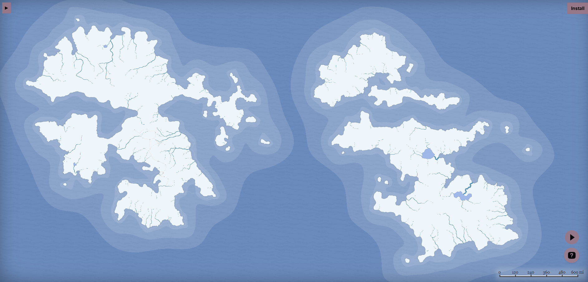
Here is an example of a map generated with Azgaar's Fantasy Map Generator v1.143.1. Something similar (though probably less robust) could be implemented for our purposes. I don’t imagine terrain, climate, or biome would need to be generated, just a simple land-or-water deal. This (and subsequent example maps) are generated with a cell-based system instead of a hex-based system.
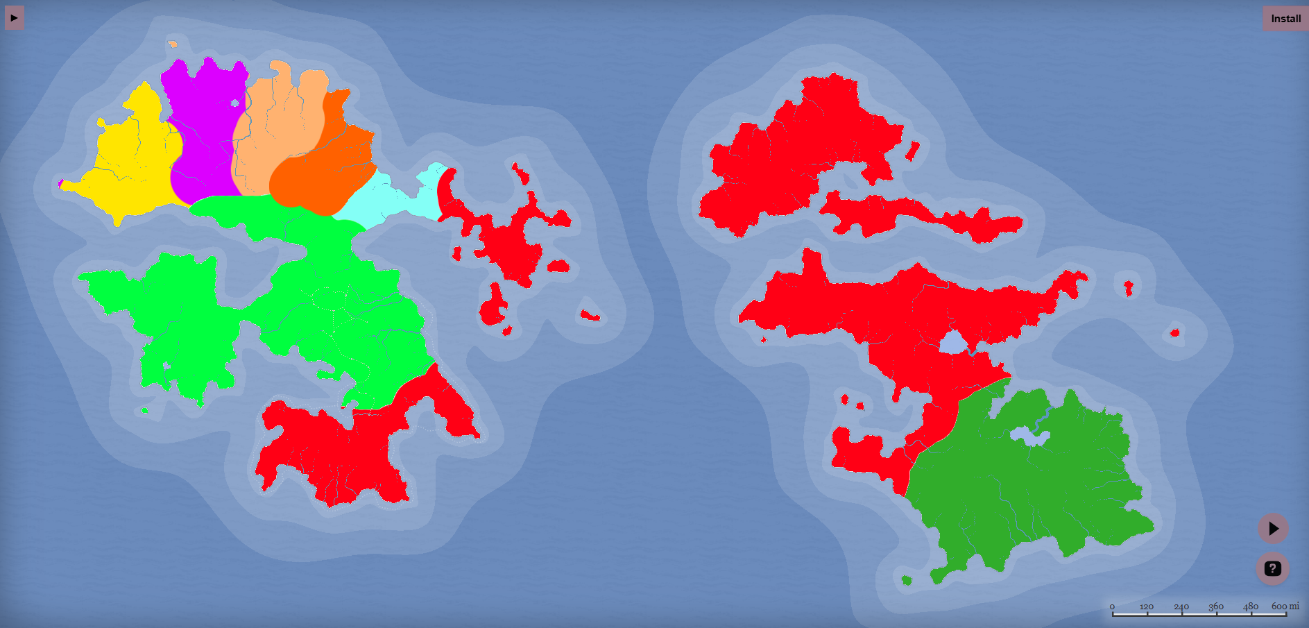
For reference, here are some sizes mapped out.
Red Empire is a Transcontinental State (45% of land area)
Lime Green and Dark Green are each Large States (20% of land area each)
Yellow, Pink, Taupe, and Orange are each Small States (5% of land area each)
Cyan is a City-State (2% of land area)
NATIONAL MAPS
When a nation joins a region, as mentioned prior it gets the opportunity to choose its spot and fill tiles on the map. I recommend some sort of system to encourage contiguousness, but that might be too specific to mention here.
I imagine that for internal borders, the large tiles which constitute the map will be subdivided into sub-tiles for demographic purposes, similar to how baronies work in Crusader Kings or how provinces work in Hearts of Iron — with counties and states respectively as the larger unit. The population of the nation will be distributed unevenly to create “urban” and “rural” tiles, and based on the economic sectors’ relative importance (percentage of economy), each sub-tile can have an economic sector (which would play into voter satisfaction within each sub-tile. I can throw together a more detailed GDD about how these systems would interplay if the Developer would like me to 😄 .
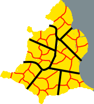
Here’s an example of how the Yellow country from above could be subdivided into tiles (black lines) and sub-tiles (red lines).
If we really wanted to go crazy, we could even add a system of provinces where players can combine tiles for sub-governmental roles like regional governors, or just for roleplay flavor. Even if such an additional system were not added, it would be neat to name tiles or groups of tiles as “regions” within the country even if there are no gameplay effects.
Cities and mayoral elections could be implemented as well, either as individual sub-tiles or as "icons” that exist within geographic divisions but are not themselves an independent sub-tile.
INTERGOVERNMENTAL UNIONS
Another feature I have seen requested often is an intergovernmental forum like the UN, EU, ASEAN, or NATO. In addition to giving great roleplay opportunity and an actual job for foreign ministers and ratification authorities, these could affect policies and stats for countries. These could exist at a region-wide level (all the nations on a given map) or more narrowly (more like the EU) — but the implementation of this idea and its complexity and intricacies is not within the purview of the present suggestion.
WHY THIS IS A GOOD IMPLEMENTATION
The combination of geography into the game’s politics is doubtless a feature that would demand intense work for implementation and require a significant commitment of time and effort, but I believe that the model laid out herein is the most efficient use of time and resources to implement the demanded features.
TIMELINE COHESION
When a cap is placed on the number of countries that have to share lore, it becomes noticeably easier to develop a coherent and dynamic world narrative, because you only need to unify and intermix 5 countries’ lore instead of 30. The narrower scope allows more authentic and risky stories to take place because there is less risk of upsetting more countries’ lore.
CONTINUITY COMPARTMENTALIZATION
One under-looked but potentially helpful feature would be the potential for different game years for different regions, so some regions could exist in the Cold War, some in the 90s, some in the 2020s, and some in the future!
Additionally, the compartmentalization of timelines allows for narratives to be protected and coexist without collision with other countries’ lore without greater effort.
ECONOMIC SYSTEM INTEGRATION
This system is as best integrated with the economic system as one could reasonably expect, I believe. I think the mixing of demographics, economics, and geography allows for dynamic and engaging gameplay that interplays innately with the core gameplay loop.
POTENTIAL EXPANSION
This tile-based system is a strong baseline for future economic gameplay changes, constituency gameplay with gerrymandering and the like, and even the much-craved military expansion so many have clamored for.
RISKS AND DOWNSIDES
The potential downsides I can see are:
the increased workload on the servers,
the storage space necessary for calculations and tracking geographic data,
the risk of overcomplicating the basic gameplay loop.
There are probably features of this that I have forgotten in the process of drafting and writing it, but if I recall any I will elaborate in the comments. Additionally, as mentioned prior, I am willing to make a GDD for more specific gameplay elements, resource flows, flowcharts of systems, etc.
Comments6
bacongaming124
Aug 17
this should be added
lawmaker-dev
Aug 17
•Merged request
•6 votes
Add a map
It would be annoying to start and for the existing states but the developer could make a map and put certain nations in different places. This would add better ways to rp and have lore as you know your neighbours. It could also support a potential trade system if the developer is interested in implementing it.
lawmaker-dev
Aug 17
At this stage I don’t know how to do this
lawmaker-dev
Aug 17
Thank you very very much for this well thought through proposal
edu
Aug 17
absolutely amazing proposal
leldy22
Aug 17
Thank you friendo